This loop hike is named after Tom Jones Mountain because it is the highest point on the loop and the location of Tom Jones shelter. This hike is one of the most popular in Harriman state park with great views and great locations for camping. It also traverses over the top of four mountains, Black Rock Mountain, Ton Jones Mountain, Parker Cabin Mountain and Car Pond Mountain.
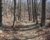
There is two parking areas you can choose from for this hike. The west area has more parking available. As usual, you can hike in either direction. I chose clockwise. From the west parking lot, cross Kanawauke Rd (formally Route 106) and look for the White Bar trail markers You may need to walk west on the road a little. The White Bar trail parallels the road for a short distance until it crosses a stream and turns right. After .25 miles the White Bar trail meets the Nurian Trail. Turn right onto Nurian and follow for .5 miles until the trail ends on the summit of Black Rock Mountain. The Ramapo-Dunderberg Trail (red dot markers) is just below to summit. Make a hard right on the R-D trail and descend .5 miles back to Kanawauke Rd.
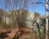
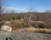
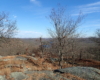
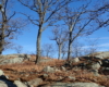
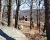
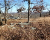
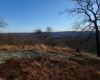
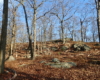
Walk along this eastern parking area following the Ramapo-Dunderberg trail and cross the road. This is a steep, rocky climb up for about .25 miles to the top of Tom Jones Mountain. When the terrain levels out you will have great views back toward Black Rock Mountain and Lake Kanawauke. The top is open with scattered trees, tall grass and glacial erratics. Very picturesque, especially in fall and when the leaves are off the trees. Further along the top are great camp sites and down on the left is Tom Jones shelter.
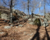
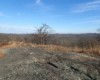
Descend Tom Jones, continuing on the Ramapo-Dunderberg trail for .7 miles until you reach the summit of Parker Cabin Mountain. Parker Cabin Mountain also has great views of Lake Sebago in the distance to the south. It is a steep and rocky descent from Parker Cabin that you follow on the R-D trail for .55 miles until you reach the White Bar trail.
Make a sharp right onto the White Bar trail and follow for 1.2 miles to a view point on Car Pond Mountain just bellow the summit. From this view point it’s another .75 miles back to the trailhead parking area where you started.