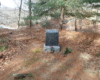
Stockbridge Mountain is an out and back hike to a nice view point and a nearby shelter. There is also a cave rock formation at the back end of Stockbridge. Start this hike from the Silvermine Lake picnic area. Walk through the picnic area on the Menomine Trail (yellow markers). At the end of the picnic are is a gate. Go around the gate and the Menomine trail turns right through some brush and enters a pine section along Seven Lakes Drive. You will see a marker in the forest for the Lewis Cemetery. The Lewis family had a homestead here in the late 1800’s. The property was sold in 1909 with the understand the cemetery could remain.
Soon after the cemetery marker the Menomine trail crosses Seven Lakes Drive. The trail passes through a gate and goes along the shore of Lake Nawahunta. The Menomine trail follows a forest road through this section until you reach a gap between Stevens Mountain and Stockbridge Mountain. The Menomine trail ends on the Long Path (turquoise markers), 1.5 miles from the Silvermine Lake parking lot.
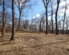
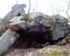
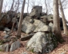
Turn right on the Long Path and ascend the steep hill to the Stockbridge Shelter. The high point is past the shelter. Passing the shelter on the right, the forest opens up with clear forest views right and left. The top is relatively flat and there is several good campsites in the area. The high point is a rock outcropping on the left with a nice view point north. Continue on the Long Path to a steep descent with another rock outcropping on the right. Passing through the rocks you will see a shallow cave on the right that can be used as a shelter or camp fire.
Return the way you came or you can turn right past the cave shelter and follow a depression which turns into an old forest road that meets back up with the Menomine Trail.