Black Mountain


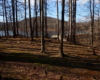


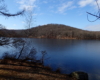


Black Mountain and the Silvermine Lake loop are very popular in the summer due to the Silvermine Lake parking area has location for picnicing. You do have to pay here in the summer but parking is free in winter and early spring.
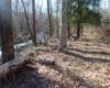
After parking at Silvermine Lake, walk back out to Seven Lakes Drive. You will need to turn right and walk the road for about .75 miles. After passing a comfort station (always closed) watch for a faint forest road on the right. This unmarked forest road is called Silvermine road, which follows the Queensboro Brook back toward Silvermine Lake. The road crosses the brook and begins a long steady climb up with great views of Silvermine Lake. After about one mile from crossing the brook, the road crosses the Appalachian Trail (AT on maps with white markers on trail) and the Ramapo-Dunderberg Trail (red markers). The AT and the R-D Trail share the same path in this section.
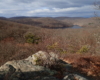
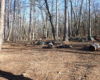
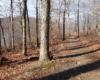
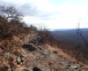
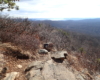
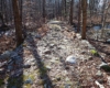
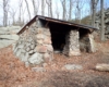
Turn left onto the AT and begin the steep climb up to the top of Black Mountain. There is many great view points along this ridge. After about .5 mile mark the trail begins to descend. This is a good point to turn back. When you reach Silvermine Road (Forest road), continue straight on the AT crossing the road. The trail weaves through the forest for 1 mile when you reach the William Brien Memorial Shelter (formally know as the Letterrock Shelter). The Menomine Trail (Yellow markers) crosses the AT at this shelter. To complete the loop, turn right onto the Menomine Trail.
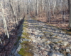
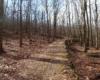
The Menomine Trail is very rocky and as you near Silvermine Lake it becomes very wet, especially after rainfall or snow melt. The Menomine Trail is 1.35 miles from the shelter to the parking lot where you started.