Appalachian Trail - Stokes South
Stokes State Forest, New Jersey
Adventure Travel
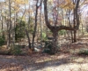
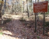
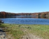
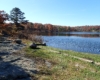
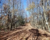
This hike can be done in either direction (north or south) along the Appalachian Trail (AT). This is a point to point hike, so either a shuttle driver or two cars is required. We chose to leave a car at Culvers Gap parking are in Stokes State Forest and drive south into the Delaware Water Gap National Recreation Area where the hike will begin. From Old Mine Road in Delaware Water Gap N.R.A. turn up Blue Mountain Lakes Road. The last 2 miles of this road is seasonal access and closes after the first snowfall. Take to the end before a sharp right where the road becomes Skyline Drive and park. Back down the road a very short distance, the AT crosses the road. Turn right (North) and follow for 1.6 miles. There you will meet a forest road (Orange markers). The AT crosses this road but it is a worthwhile detour to Crater Lake for a nice view and pit toilets.
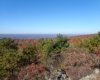
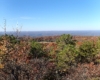
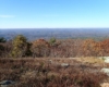
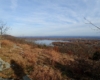
To go to Crater Lake, turn right and follow for .5 miles to the parking lot. The forest road continues around the lake and back onto the AT in .4 miles. Turn right onto the AT. The AT follows this forest road for about 1.2 miles. After the trail goes back to single track, hike another 1.6 miles to the top of Rattlesnake Mountain with nice views to the west. In another .8 miles you ascend Bird Mountain for more good views to the west.
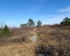
Descend Bird Mountain and hike another .75 miles to Blue Mountain. As you begin to Ascend Blue Mountain, you cross over in the Stoke State Forest. The next 4 miles has some up and down hills and not many view points until the very end before your descent to Culver Lake. This entire sections of the AT is very rocky and sturdy hiking boots are advised.