Graduated ND filter (recommended for unique photo opportunities)
Hike Info:
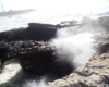
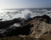
Very easy trail. Area at the cliffs is rugged but can be explored.
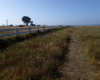
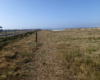
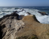
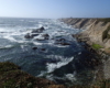
This trail is marked as hiking but there is no name for it. I call it the Lighthouse Trail because it starts at the entrance of the Point Arena Lighthouse to the right and goes along a white fence separating the Lighthouse property from the Stornetta Public Land. The trail, continues along the fence near the end then turns right along the coast. There is a cove and two points you can walk out to. The first has a blowhole of sorts and at high tide is nice to watch. The trail continues around the cove to the other point. A very peaceful hike and in mid June there were plenty of spring flowers blooming. Perfect to watch the sunset.
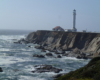
Come early to check out the Point Arena Lighthouse. It is situated on the piece of land that is the closet to the Hawaiin Islands from the continental United States. The lighthouse stands at 115 feet high and you are able to go to the top. I did not have time for this, unfortunately, but definitely something I will take advantage of on my next visit. The lighthouse and museum are open daily from 10am to 3:30pm but between Memorial Day and Labor Day they stay open until 4:30pm. The cost is $7.50 for adults and $1.00 for children (2015). There is also the Lighthouse Keepers vacation rental house where you can reserve and stay over night. This sounds like something I would also like to do.