Menu
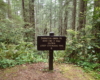
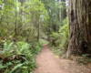
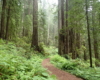
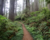
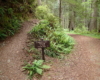
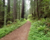
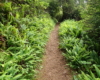
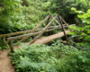
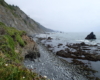
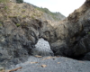
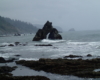
DAMNATION CREEK TRAIL
Del Norte Coast Redwoods State Park


DETAILS

Directions:

From Crescent City, the trailhead is about 10 miles south on Route 101 from the center the city.  There is a large pulloff and a small mile maker sign that has “16” on it.

Equipment:

  • Sturdy hiking shoes
  • water
  • camera
  • food/snacks

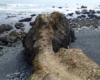
Hike Info:

The trail is steep but easy to follow and well maintained.  Watch for rising tides if you go out onto the stone beach.

The Damnation Trail is the most difficult trail in Del Norte. The trail head is on Route 101. From that point, the trail descends 1100 feet in about 1.4 miles. Not bad when going down at the beginning but you eventually have to hike back up. The trail end at the beach and the Pacific Ocean. The trail crosses the Coastal Trail at an especially beautiful area. Before this point are larger old growth redwoods. That tends to thin out as you descend. Also before this point you can still hear cars driving on Route 101. Past the Coastal Trail, as you continue to descend you begin to hear the waves of the ocean crashing on the beach.


The Damnation Trail ends at a gravel beach on the Pacific Coast. The trail goes out on a point by a narrow trail which is actually over a small arch. But to get down to the beach, there is a trail on the north side just before going out at the final point. The ocean is a bit rough and there is a lot of rock in the water. I tried to look in the few tidal pools but the rock is very slippery and the area is not very big. There is plenty of solitude which is nice while listening to the ocean crash on the rocks. However I was here at low tide and I’m sure you should go to beach level at high tide.

The hike back up is difficult. I did this hike late in the afternoon and there was no one else on the trail. Actually the trail is so difficult I don’t imagine you would see many people any time of day.


Post Views: 334