Menu
BEAR MOUNTAIN TRAIL
Sedona, Arizona


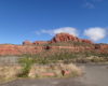
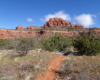
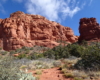
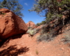
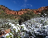
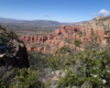
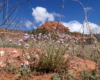
DETAILS

Directions:

Take Dry Creek Rd to Boynton Pass Rd. Turn left here. Drive to Boynton Canyon Rd and turn left. Continue here for several miles passing the Fay Canyon parking area on the left. The next parking area on the left is Doe Mountain/Bear Mountain.

Equipment:

  • Sturdy hiking shoes
  • camera
  • sun protection
  • extra water
  • food/snacks

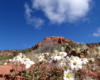
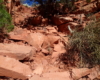
Hike Info:

Steep but well defined trail.  The upper plateau trail can be difficult to follow.  Watch for small cairns.

Bear Mountain is one of the more difficult hikes in Sedona and has very easy access. There is a parking area between Doe Mountain and Bear Mountain. The trailhead is across the street and the initial approach is very flat. The red rock bluff you first see on the approach is only part of Bear Mountain and not the top. In guide books, the trail is stated to be about 3 miles to the summit and then return the way you came for a total of 6 miles. The trail does go beyond the 3 miles across some interesting slick rock formations. At this point the trail is marked by cairns so if you want to explore beyond this point be mindful and watch for them. The top has several false summits and it is very easy to think you are at the top when you are not.


When you start the ascent there are some great views of Doe Mountain across the way.  The trail has several “steps” or benches where the trail is relatively flat between steep climbs. Some people count 5 of these steps and some count 4. The steep sections are very rocky so be careful, especially on the descent. This makes it very difficult to find the top. If you do not have a GPS with a topographical map, I would suggest to hike to a point where you feel comfortable and return.

Because of the length and steepness of the trail, I also recommend doing this hike very early in the morning to beat the heat of the day.


Create Routes
or Search for a route
from millions at MapMyHike
Post Views: 401