
Flagstaff, Arizona
TWO-SPOT TRAIL
Adventure Travel
|
DETAILS Directions: Take Historic Route 66 west from Flagstaff and turn south on Woody Mountain Road. Travel 7.4 miles to the first (or north) trailhead, and travel another 1.1 miles to the second (or south) trailhead (or 8.5 miles from Route 66) Equipment:
Hike Info: Short easy trail that is well maintained. Be sure to close the cattle gates after passing through |
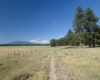
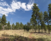
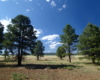
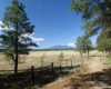
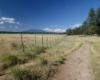
This loop trail has two different starting points. You can start at the south end of Rogers Lake or the north end. I chose the south and went in a clockwise direction. This is recommended if you are hiking in the late afternoon as I did. The sun will be at your back during the section that has full exposure to the sun. This direction also offers great views of the San Fransisco Peaks. The trail is flat and easy the first mile along the lake, which had hardly any water that can be seen from the trail. It is more of a basin that fills after the winter melt.
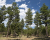
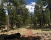
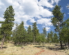
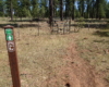
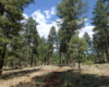
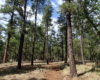
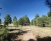
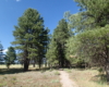
After the first mile, you reach the northern parking area and a viewpoint. Cross Route 231, and to the right you’ll see the trail ascend slightly into the forest. There is a cattle gate to pass through. Be sure to close the gate and latch the chain. This type of gate is at both ends of the forest section. The trail meanders through the trees back south to complete a pleasant loop of about 2.6 miles.


Below is the loop hike that incorporates the Two-Spot Trail