
GOLD DIGGER TRAIL
Adventure Travel
|
DETAILS Directions: Take Historic Route 66 west from Flagstaff and turn south on Woody Mountain Road (FR 231). Travel 7.4 miles to the first trailhead or travel another 1.1 miles to the second trailhead (or 8.5 miles from Route 66). Equipment:
Hike Info: Trail is well maintain but can be tricky just before descending after the Ramada. |
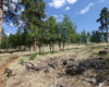
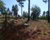
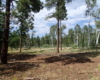
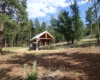
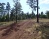
The Gold Digger Trail is about 4 miles long. You can only access this trail from the Two-Spot Trail as it branches off and ascends/traverses the side of Woody Mountain but never comes near the summit. I used this as part of a loop hike with the Two-Spot Trail in a clockwise direction. The trail is easy to find and begins to gradually ascend as it crosses several forest service roads. There are trail markers only when it crosses a forest service road. After about two miles, you’ll reach an aspen grove and a Ramada with picnic table and water collection feature. This is a good place for lunch.

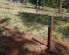


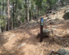


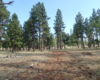

After the Ramada, the trail climbs a hill crossing over another forest service road. As you top out on this hill, the trail appears to turn left with a single large cairn. This well-worn and traveled trail is the wrong way! It seems to be a mountain bike trail but I could not find any information about it. The trail that looks less traveled and turns slightly right and downhill is the Gold Digger Trail. There was no marker, and I went a bit out of the way until I realized I was going the wrong way and turned back. See the route below and avoid the left turn to nowhere.
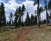
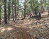
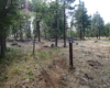
From that point, the trail has a gentle descent through an open forest. This is a prime area to encounter elk however, I did not see any during my late afternoon hike.
Below is the route as part of a loop hike with the Two-Spot Trail: