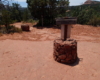
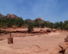
Soldier Pass Trail begins at the end of Shadows Canyon Road in Sedona. There is a parking area here. The trail climbs gradually for about .25 mile when you reach Devils Kitchen, a sink hole with a large block of sandstone balanced on the side. About another .25 mile up the trail, you’ll pass a series of seven potholes carved in the sandstone by water runoff.
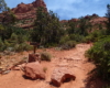
The trail continues uphill and begins to get steeper. After about one mile from the trailhead, you can see Soldier’s Pass Arch. Because of the open country, this remains in view for another half mile as the trail begins to get very steep. The Arch is difficult to spot but at mid-day you can clearly see light shining on the ground behind the arch. Access to the arch can be gained from the Brins Mesa Trail.
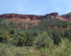
The trail begins to even out and turn to the right where it will end on the Brins Mesa Trail. Turn back the way you came or turn right and follow Brins Mesa Trail to the Cibola Pass Trail, turn right again until you reach Soldier Pass Trail for a long loop hike.
Below is the trail as part of a loop hike with the Brins Mesa Trail from Vultee Arch Road.