Menu
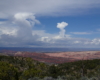
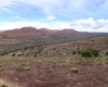
Vermilion Cliffs National Monument, Arizona
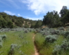
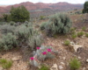
ARIZONA TRAIL - STATELINE


DETAILS

Directions:

The easiest way to get to the trail head is from Utah and route 89.  From Route 89, take House Rock rd. Pass the Buckskin Gulch and Wire Pass Trailheads. Continue until you reach the Stateline Campground on the right and park there. 

Equipment:

  • Sturdy hiking shoes
  • water
  • camera
  • sun protection
  • food/snacks

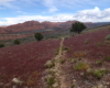
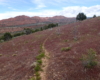
Hike Info:

The trail ascends steadily for the entire 4 miles out on a faint by identifiable trail.  Be prepared and watch for changing weather conditions.

Hike the start (or end) of the Arizona National Scenic Trail from the Utah border. Enjoy beautiful wildflowers in late spring and summer.

Depending how you approach this 800 mile trail, I did the first 4 miles or last 4 miles as an out and back from Stateline Campground on the Utah/Arizona state line and the border of Vermilion Cliffs National Monument. This section of the trail does not pass through Vermilion Cliffs N.M. but offers amazing views of the mountains in the park. The trail is difficult and seldom hiked. It is a steady climb to the top of a mountain. Late May and early June are a perfect time to hike this trail because of all the wildflowers that are blooming. I hiked until the first back country dirt road that intersects the trail. It is easy to find your way along the trail and there are plenty of switchbacks along the way to make the climb easier.


In total this was a little more than 8 miles round trip. A trail I would definitely hike again, especially to see the wildflowers with the Vermilion Cliffs in the background.


Post Views: 569