Menu
PUEBLO LA PLATA TRAIL
Agua Fria National Monument, Arizona


DETAILS

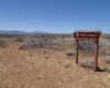
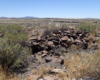
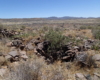
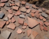
Directions:

Take exit 259 off Route 17 from Phoenix. Turn right on Bloody Basin road and follow for 8.5 miles. Pueblo La Plata is on the left and a sign marks the way.

Equipment:

  • Water
  • Sun protection
  • camera
  • Light hiking shoes

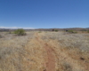
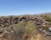
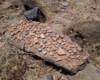
Hike Info:

The trail is very easy and short to the ruins.  Leave No Trace.  Do not disturb the artifacts.

Pueblo La Plata is the largest ancient Indian ruin in Agua Fria that dates back to before 1200 A.D. The ruin at one time had 80 to 90 rooms for living quarters of the people. Now the sight seems like just a pile of rubble. However there is significant research continuing on the mesa of Agua Fria which has about 400 sites. The community was quite large.


Today, few people visit the site because of the difficulty to get here. A high clearance 4×4 is required to get to the trailhead or you can walk the 2 mile road from Bloody Basin Road. There are many artifacts remaining in the area. Please practice “Leave No Trace” principles and do not take anything from the site. By the way, it is illegal to remove artifacts from an archeological site on federal land.


Create Routes
or Search for a route
from millions at MapMyHike


Post Views: 449