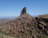
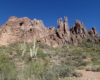
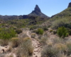
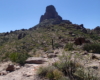
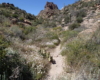
Menu
WEAVER NEEDLE LOOP
Superstition Wilderness, Arizona


DETAILS

Directions:

From Phoenix, take US Route 60 east to East Peralta Road in Pinal County.  Drive to the end of Peralta road for the trail head.

Equipment:

  • Sturdy hiking shoes
  • At least one gallon of water
  • sun protection
  • Map/navigation
  • trekking poles
  • long pants.
  • food/snacks

Hike Info:

While the trails are easy to follow, they are only marked at trail junctions.  Hike has full exposure so stay hydrated and protect yourself.

Great desert scenery in historic Superstition Wilderness. Circumnavigate Weaver Needle on this 13 mile loop hike.

This is a difficult hike! Plan on a lot of time and an early start. I did this hike in a clockwise direction which really doesn’t matter much but I recommend the direction to get the steepest part of the hike done first. Most people just do an out and back hike to Freemont Saddle to view Weavers Needle. This is the first section and very steep. If you are doing the loop plan on a 7am or 8am start. Much of this first section will be in the shade at this time.


Weaver Needle Loop Weaver Needle Loop


From the Freemont Saddle, the trail descends to the left. I enjoyed this section as you have great views of Weavers Needle the entire way. The trail is also relatively easy to follow at this point. To continue the loop, the Peralta trail will meet the Dutchman Trail. Take the Dutchman Trail to the right for 1 mile. This has a difficult, rocky up hill section.

After one mile on the Dutchman Trail you reach a post with a sign directing to the Terrapin Trail. This section feels like the longest and never ending. There is also a point when you loss sight of Weavers Needle for the remainder of the way. You will see several side trails to the right which lead to views of Weavers Needle. There is one that looks like you are continuing on the Terrapin Trail and will take you up a steep climb to a saddle and a view of the needle. This trail is marked along the way with cairns making you think you are going the right way. YOU ARE NOT! This is the wrong trail. The Terrapin Trail never goes on the direction toward the needle. This is why it is important to have a good trail map.

Eventually you reach the trail junction with Bluff Springs Trail. From here it is back to the trail head but this section is longer than you think. Much longer. Every time you breach a hill you think you will see the parking area. It was defeating.

I tracked the loop at 12.5 miles with an altitude gain of about 3000 feet in total.  I’ve seen other posts that have it at 13.1 miles.  Either way it is a difficult hike!


Create Routes
or Search for a route
from millions at MapMyHike


Post Views: 886